Wednesday 27 April 2016

Seat No. 36 - Kumily


Kumily
Explore the untrodden roads that holds very rich, exciting and enriching experiences!


Why don’t you just take a direct bus from Bangalore to Kottayam? This was the question posed to me by my friends.

Dear Friends, you are correct ! The direct bus from Bangalore to Kottayam takes less than 12 hours and best done overnight to reach next day morning hours.

Then why on earth did I choose an unconventional route. There are a few reasons like buses and trains being full on the usual route and then a nagging soul that keeps reminding me that this is a new route via Theni Cumbum and Kumily!

So I did take a chance & I did travel on 22nd April 2016… yet another first but unconventional  route : Bangalore – Salem - Namakkal  - Dindigul –  Theni – Kumily – Mundakkayam – Kanjirapally - Kottayam.

Route map - Bangalore to Kumily via Salem Dindigul Theni


Where is Kumily?
Kumily is the largest Gram Panchayat in Kerala. Kumily is a town in Cardamom Hills near the very famous Thekkady and Periyar Tiger Reserve, in the Idukki District of Kerala. Kumily is known as Gateway to Thekkady and it is also known as the Spice Capital of Kerala. Kumily lies in the National Highway 183 that connects Kottayam through Mundakkayam and Kanjirappally. The state of Tamil Nadu borders the town. It is a major tourist destination and a spices trading centre. The nearest airport is Madurai (125 km) and railway Station is Theni. The famous pilgrim centre Sabarimala is 150 km from Kumily.  Kumily is well connected with Kottayam and Kochi.
Kumily is always a special destination for most of the tourists due to its climate. Nearby Tamil Nadu district is Theni, where tourist can see grapes cultivations in large acres. Kattapana is the nearby municipality. Famous tourist attractions nearby are: Thekkady, Anchuruli, Ottakathalamedu, Kalvery Mount, Vagamon, Pine forest, Kalyanathanddu.

Kumily


My plan of action: I took the Atlas Tours bus from Bangalore at 20:00 hrs. Seat number 36.. the first and single seat on the left side. Only plus point was unhindered views of the landscape ahead! The bus was just okay…  it was not punctual & not air conditioned! Taking such a bus is not a great idea especially when Bangalore is a boiling cauldron in April - thanks to a fabulous summer. Fabulous only for the retailers who offer fabulous summer discounts to gullible customers!

2200 hrs : We had dinner at Krishnagiri : This place has a hotel and facilities to freshen up.

Tip: Recommending a private taxi or own vehicle to travel from Bangalore to Kumily so that you can stop at a hotel with 3 star or higher facilities for food or stop at your will and enjoy breathtaking scenery!

2345 hrs : The bus stopped! Probably the driver felt groggy after driving for 6 hours. Surprisingly there was no alternate driver. The conductor in this bus was more of a specialist and would only open / close the doors and handle passenger luggage.

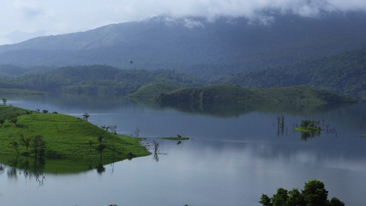
I did my best to sleep. But I woke up to the sound of gushing water at around 0545 hrs – I could see huge pipes from the hills carrying water to the hydroelectric project. We crossed parts of Periyar national Park, Western Ghat mountains and voila... we entered in to Kumily! 
I must have also seen Meghamalai - but we will save Meghamalai for another day!

0600 hrs @ Kumily Town : We stopped for a morning tea ! I noticed that almost all shops advertised about spices - cardamom, cinnamon, cloves and all kinds of tea.


Kumily Town

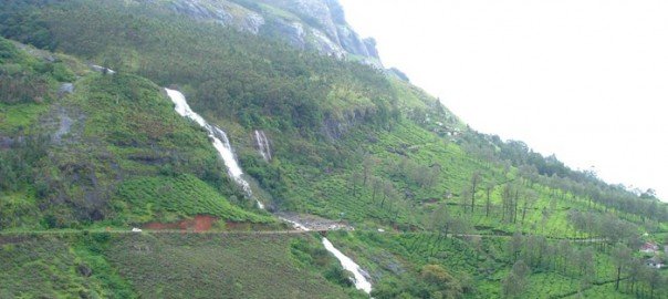
Mother Nature has been bountiful and beautiful for Kumily. 

Kumily, with its lush green plantations and its aromatic spices, is an enchanting place. However, the neighboring places like Vandiperiyar, Vandanmedu, Murikkady and  Chellarkovil will offer you equally or perhaps more beautiful sights and experiences. As you  drive along the serpentine roads and the wicked hairpin bends of these places, Mother Nature reveals herself in a hundred ways and a thousand hues. 

Kumily
Rest of the journey from Kumily to Kottayam was completed within 3 hours. We traveled through interesting places like Peeramedu, Mundakkayam, Kuttikkanam, Kanjirapally.
  
Kuttikkanam is a village in Idukki district, Kerala, southern India. It is 3,500 feet (1,100 m) above sea level and surrounded by lush green tea plantations. It is within the territory of Peermade. Kanjirappally and Mundakkayam are the nearest cities.

I have decided to visit Kumily & Kuttikkanam again as there are lot of places to explore ... I will share those experiences on another post. Good bye for now and have a great week ahead!

Kumily

Monday 25 April 2016

V for Vagamon - W for Wanderlust

He wanted his friends to realize that life is a journey and not a destination - Simon Peter

Vagaamon tea estate - you can purchase farm fresh tea here.
Vagamon happened last week (April 24, 2016) by sheer chance ! I will explain that. My wife had suggested and planned a visit and lunch at Misty Mountains, Kuttikanam, Idukku district. However we had certain challenges in terms of logistics and availability of time and so we decided in favor of Vagamon.

Where is Vagamon?
Vagamon is a hill station located in Kottayam-Idukki border of Idukki district of Kerala, India. It has a cool climate with the temperature between 10 and 23 °C during a summer midday. It is situated 1,100 metres above sea level. Vagamon was discovered by the British who found the place ideal for tea plantations and they were followed by Christian missionaries who built their abode of service at Kurisumala in Vagamon. National Geographic Traveler has listed Vagamon on their directory of the '50 most attractive places to visit in India’

On the way to Vagamon - a brief stop over for some breathtaking views of the plains and hills
How did we reach Vagamon? 
We decided to drive down to Vagamon from Kottayam. 
We started from Kottayam by 1200 hrs. The roads are drive-able and in good condition.
1300 - 1400 hrs Lunch break:  We first touched Pala and stopped for lunch. The lunch was simple and served on plantain leaf. We finished lunch and soon started driving towards Vagamon. We passed through Erattupetta.

Vagamon is at the fringe of the Western Ghats and the foot hills on its lower side reach up to Teekoy with a gradual descent. This narrow strip of descending land gives a much needed and strategic connectivity to the plains as both sides of Vagamon up to Kuttikkanam on the south west and moolamattom on the north east, are marked by steep and inaccessible hill slopes. Travelling by the hill highway in this section is an exhilarating experience with deep valleys and spectacular 260 degree views with an ethereal touch. Vagamon's charm is worth experiencing and is indeed one of the must see places in Kerala and India. 

Vagamon tea estates
Reaching Vagamon itself is an extraordinary experience. The meandering ghat roads to Vagamon is cut in solid rock lined with forests. And as you wind your way through green capped hills, the rolling plains come into view thousands of feet below you. The road to vagamon from Erattupetta (Erattupetta also known as the gateway of Malanadu) opened an easily accessible and direct route to vagamon from the plains. 

1600 hrs Tea time :  We stopped for tea at Eco park.
Tasty bites - Vazhakkapam - banana fry and tea


Eco park is a nice place before Vagamon. Our host Marykutty chechi did not disappoint us. She instructed her staff to quickly bring piping hot vazhakkappam (banana fry) and steaming hot tea. While I was putting away these  goodies, my children asked their aunt, mother & grandparents to show them around the Eco park which boasts of a small lake and farm animals.
Vagamon tea estates
My children demanded a look at the horse and cattle. We walked in to the Vagamon tea estates and were presented with beautiful scenery of tea estates. My children urged me to stay for more time as they spotted two calves who were happily munching on the sweet grass.


Image result for jeep rally vagamon
Jeep rally - off road events are conducted in Vagamon
We finished tea and set off for the road. At about 1700 hrs we reached Vagamon. There are 2 roads . One on the left takes you to Vagamon town. We took the other road turning right as it has got awesome tourist attractions. We also chanced upon an off road event - a Jeep rally. We saw MM540DPs, Willys and Gypsies roaring and setting fire the Vagamon roads!

Mottakunnu - Vagamon

1715 hrs : It was getting colder and we quickly trekked on to mottakkunnu in Vagamon. This place offers a complete view of the neighboring hills.
Tip: Avoid trekking the Vagamon hills during rains and lightning. There have been recent incidents of lightning striking tourists.

1800 hrs: The fog started setting in. (the dense fog is known as koda manj in malayalam). We bid goodbye to Vagamon and started back for Kottayam. En route, we did stop to buy farm fresh tea at Vagamon Tea estate

There are many tourist places in and around Vagamon like Kurisumala Ashram, Indo-Swiss Project Dairy Farms, Vagamon Meadows, Pine Forest valley, Mooppanpara. However, we decided to visit these places next time ... may be stay back a night in a good resort at Vagamon and chalk out our plans for these places!

It is good bye for now and wishing you a great week ahead..

@ Vagamon - a driver maneuvering the winding roads.. undaunted and unfazed by the challenges ahead - the unsung hero of Vagamon

ike 

Monday 18 April 2016

Banasura Sagar - Wayanad


Explore the untrodden roads that holds very rich, exciting and enriching experiences!

Part 2 - Day 2  - Visited Banasura Sagar Dam  ,Wayanad on 17 April 2016


I started at 0730 for Banasura Dam after checking out of Mint flower. This as per advice from Jiji who agreed to take me around on his Jeep. Why a Jeep taxi - Wayanad has a hilly terrain and in certain areas - it is Just non-metal roads  & only a Jeep can do Justice!! This is my perspective!

Tip  : Tourist spots are far away at 45 - 50 km one way from Sulthan Bathery / Kalpetta in Wayanad. So the traveller needs to start early ! Hotels also provide Tata Indica and Mahindra Verito taxis also, which might be more comfortable.

Jiji was curious and asked me the reason for myself being a lone traveller. I was only happy to explain that I come from a concrete jungle city Bangalore and that I needed a break ! We started chatting and became good friends. Jiji mentioned about his concerns on environment specifically on deforestation and water scarcity. He did mentioned that there used to be huge trees (in Wayanad) with width where in even 5 persons could not cover it by holding their hands together. Today trees have disappeared... Rains are still awaited and there is an impending water scarcity. He also mentioned that during his school days, he used to boil water in large utensils and then place the diesel in a steel vessel in the middle of such utensils. He then used to pour the heated diesel and hot water into his jeep as per his fathers instructions. Gone are those days when Wayanad used to be colder. 

Jiji went full throttle on his Jeep and we reached Banasura mountains by 0845 hrs. I asked Jiji to stop at a usual and good thattukada (thattukada is a small shop giving food takeaways and quick bite). Luckily there was a decent one at the base of Bansura hills and I was able to tuck in puttu  and velle appam (rice cakes)

0900 hrs: We reached the entrance of the Banasura Dam.
Tip: Jeeps are available at the entrance to ferry visitors till the dam area for INR 50. 
I was happy to walk this 1 km stretch and was rewarded with beautiful sights of the dam.   
The road from entrance to Banasura dam
Location: The Banasura Sagar Dam is located 21 km from Kalpetta, in Wayanad District of Kerala in the Western Ghats. It is the largest earthen dam in India and the second largest in Asia and an ideal starting point for hikes into the surrounding scenic mountains. It is an important tourist attraction. Banasura Sagar Dam is at the foot of the Banasura Hill. The dam has become a popular tourist destination. Many people visit the place to go trekking at the Banasura Hill. The Banasura Hill Resort, located about 20 km from the dam was rated as Asia's largest Earthen Resort by BBC. 

About Banasura Sagar Dam
Banasura Sagar Dam, which impounds the Karamanathodu tributary of the Kabini River, is part of the Indian Banasurasagar Project consisting of a dam and a canal project started in 1979. The goal of the project is to support the Kakkayam Hydro electric power project and satisfy the demand for irrigation and drinking water in a region known to have water shortages in seasonal dry periods. In the dam's reservoir there is a set of islands that were formed when the reservoir submerged the surrounding areas. The islands with the Banasura hills in the background provide a spectacular view. It is the largest earth dam in India and the second largest of its kind in Asia. The dam is made up of massive stacks of stones and boulders

Now for the action  : Speed boats & pontoon boats are available & are popular with tourists. Speed boat ride, in particular, is an exhilarating experience & not to be missed. 


I  teamed up with two other tourist groups from Tirupur and Kozhikode and we took the slower pontoon boat with capacity 20 people. Advantage pontoon boat : You can spend more than 30 minutes time in the lake .. a more relaxed boating experience. The speed boat is very fast and you may just get less than 15 minutes during the tour of the lake.

We all wore the safety jackets, and remained seated on the  boat. With a roar, the boat's powerful Yamaha engine revved and we started going around the lake. 

The sight of massive green mountains appearing to touch the sky contrasting with the beautiful blue water of the lake makes for a life time experience. We breathed the oxygen rich air, felt rejuvenated and headed back to the starting point

Sharing the video of this boat ride on https://youtu.be/qda3Y5tQxFk 


1100 hrs: I had to say good bye to Banasura dam. I was told by Jiji to start before 1100 hrs so that we could reach and cover Kuruva dweep Islands!

Steps from the dam also offer different views.
Tip - Avoid going near the rocks and boulders for selfies as the rocks and boulders near the lake provide shelter to snakes - poisonous snakes !! Also try using the steps near the dam to descend and explore the route - this joins the same road towards entrance.  

Dear Friends, Please do watch this space for Part 3 - Kuruva Dweep island!  

Sunday 17 April 2016

Wayanad trip - Reloaded with EDAKKAL CAVES


Day One – Edakkal caves - visited on 16 April 2016

Video of Edakkal caves :https://youtu.be/iDLQj_DZS4E 
Video of Ambukuthi hill range : https://youtu.be/_M3JaGvVQtw


I took the aanavandi Kerala state RTC from Bangalore at 0800 and reached Sulthan Bathery by 1400 hrs . I checked into Mint Flower by 1500 hrs. This is a good and economical option. The staff immediately suggested that I take an auto or jeep  taxi and reach Edakkal caves which is 14 km from Sulthan Bathery in the Wayanad district of Kerala in India.

I took an auto taxi at 1510 hrs . Soon became friends with Ali bhai who readily agreed to speed up his auto taxi to reach Edakkal caves on time. Thanks to Ali bhai we reached Edakkal base area by 1530 hrs. The ticket sales close by 1600 hrs and no entry to tourists to the caves after 1700 hrs.
Now the adventure started as I started trekking towards the caves (which lie 1,200 meters above sea level). This is a steep climb and at various times you need to engage your 2x2 wheel drive .. your hands and legs together. The climb is so steep at certain points that you will need to hold the rock formations with your hands to avoid falling. Steps are provided at certain stretches (where they can really be fixed!!).

Tip : 1. Please avoid carrying any bags or rucksack as you will not be able to manage such things during a steep climb. Water bottles need to be affixed with a ticker at the Edakkal caves office base/ticket counter. 2 . It is a better option to take a ticket for the camera as photos via phone are not allowed inside caves. 3. Please plan minimum 3 -4 hours including ascent, descent and travel for a trip to Edakkal caves. 

Exiting from first cave
As I progressed, I reached the first set of caves. This is a selfie yugam and trekkers/tourists were clamoring for selfies.

As we exited the first set of caves, I noted that the second set of caves were much higher up and even more challenging. Soon I could hear comments from fellow trekkers – Oh My God ! I am sure all mys sins from this birth/janma will be washed away and forgiven after completing this trek! Certain others were disappointed as they only noticed big rocks and wondered if this was it for them. Perspectives differ! 

The second set of caves are on the top most point and are bigger and have various inscriptions on the cave walls suggesting prehistoric in habitation. The views from this view point of Ambukuthi Hills are breathtaking !
The second cave at the topmost point of the hills in Edakkal 


Where is Edakkal Caves  : The Edakkal caves are two natural caves at a remote location at Edakkal, 25 km from Kalpetta & 14 km from Sulthan Bathery in the Wayanad district of Kerala in India's Western Ghats. 
Ambukuthi Hills
They lie 1,200 metres above sea level on Ambukuthi Mala, beside an ancient trade route connecting the high mountains of Mysore to the ports of the Malabar coast. Inside the caves are pictorial writings believed to date to at least 6,000 BC from the Neolithic man, indicating the presence of a prehistoric civilization or settlement in this region The Stone Age carvings of Edakkal are rare and are the only known examples from south India


Prehistoric carvings inside Edakkal caves
Significance of petroglyphs : Edakkal caves are not technically caves, but rather a cleft or rift approximately 96 feet (29 m) by 22 feet (6.7 m), a 30-foot-deep (9.1 m) fissure caused by a piece of rock splitting away from the main body. On one side of the cleft is a rock weighing several tons that covers the cleft to form the 'roof' of the cave. The carvings are of human and animal figures, tools used by humans and of symbols yet to be deciphered, suggesting the presence of a prehistoric settlement.
The petroglyphs inside the cave are of at least three types. The oldest may date back to over 8,000 years. Evidences suggest that the Edakkal caves were inhabited several times at different points in history. The caves were discovered by Fred Fawcett, a police official of the erstwhile Malabar state in 1890 who immediately recognized their anthropological and historical importance. The paintings point out to connections to Indus Valley civilization.

View while descending from the hill top

Now for the descent :  Descent is through steps till a common point from where the route is the same that was taken for entering the caves. I was very tired and took fresh lemon soda .. and also bamboo rice payasam (மூங்கில் அரிசி
moongil arisi, മുള അരി
muḷa ari, ಬಿದಿರಿನ ಅಕ್ಕಿ
Bidirina akki, వెదురు బియ్యం
Veduru biyyaṁ). Bamboo rice paysam is a must have. It gives you the much needed energy for such challenging treks.


It took me about less than 30 minutes for the descent. Our Ali bhai was patiently waiting for me.  When I told him about the blog post and that I will be writing about him, he was very happy and excited.  He took me to a nearby Jain temple which was under Archaeological Survey of India. The Bathery Jain temple was quite interesting with its beautifully carved Pillars, architectural peculiarities. This visit was a bonus and not planned by me or Ali Bhai at the start of this journey!


Jain temple at Sulthan Bathery, Wayanad
The Jain temple at Sultan Bathery is believed to have been built in 13th century. The architecture of the temple has strong influences of the then Vijayanagar architectural style and it is made wholly of granite.

The carved square pillars built on a raised platform holds the stone slab roof and intricate cornices on all the sides and the exquisite carvings on the pillars are a connoisseur’s delight. A square granite slab with a carving of Mahavir Jain can be seen in the inner sanctorum of the temple which is surrounded by an open verandah.  There is a raised platform made of granite in front of the main entrance. This too holds carved pillars and their fluted columns end without any crown stones. The surrounding grounds too are paved in granite.


A for Ali's Auto taxi 


At around 1800 hrs, I told Ali bhai to drop me to Mint Flower ... It was time for me to cool my heels and prepare for Day 2 - Visit to Banasura Dam and Kuruva dweep Island.


Watch this space for Day 2 - Part 2!

Thursday 14 April 2016

Kodajadri via Kollur


Today, I will share about my trips to Kodajadri/Kodachadri
Kodajadri -  Mother Nature Unlimited

First things first: Where is Kodachadri  ?
Kodachadri is a mountain peak with dense forests (elevation - 1,343 metres above sea level in the Western Ghats in South India (Shivamogga Dist., Karnataka State). It is declared as natural heritage site by Government Karnataka and it is 10th highest peak of Karnataka.
Kodachadri forms a background to the famous temple of Mookambika in Kollur. It is located at a distance of 21 km from Kollur and 15 km from Nagodi village, in Hosanagara taluk.  It is situated in the middle of the Mookambika National Park and considered as a biodiversity hotspot. The important animal life include Malabar Hornbill, Indian tiger, Indian leopard, Indian elephant, gaur, Indian rock python

Now let me share my experiences   
I distinctly remember when my friend Rameshji suggested that we do a trek from Kollur to Kodajadri. This was in mid 2006. We did go to Kollur and luckily met 2 other groups who were going to trek through the forest route into Kodajadri. 

We started around 1400 hrs ... it was not an easy trek as the path was small and day light was fast disappearing. Somewhere around 1600 hrs our self proclaimed leader (who had trekked on this route 2 - 3 times), announced that we are not on the correct route. My heart skipped a beat as it was getting dark. 

I remember imagining a scene of a few tigers happily devouring us for dinner!  However the goddess Mookambika had better plans for us, our leader set us back on track and we reached Kodajadri by 1800 hrs - completely tired and exhausted.  We were served simple and yet good food by the priest. We stayed at an inspection bungalow. 

I remember that we must have slept before 2100 hrs thanks to our exhausted state. We woke up early and were greeted by panoramic views of Kodajadri. We had breakfast and started off for Sarvajnapeetha which took us about an hour. This is the highest peak and you can see clouds. I also remember seeing lighting originating from far away clouds. 
Kodajadri -  Mother Nature Unlimited


We spent a little time for meditation at Sarvajnapeetha and started back to Kodajadri temple. We had certain jeep taxis willing to take us back to Kollur. My friend Rameshji was not feeling well thanks to the winding and hair pin roads. We could make it back to Kollur within an hour and half. Our thoughts were now on how to reach back to Mangalore and attend the office next day!   

I did go to Kodajadri again with my friend Ajesh (& his freinds) and also Prakash, Sumesh. However we stayed at Kollur and utilized jeep taxi for reaching Kodajadri. This is a more suitable and feasible option for those of you who do not wish to be the dinner of wild animals! 

Why Kodachadri is so enchanting  Kodajadri seems to have attracted the attention of mankind since early prehistory. Several monolithic structures were built here in prehistoric times. Rocks with dimensions greater than 12 feet were used in their construction. These large structure can be found just 20 Kilometers outside of Nagara-Nilsakal.   A temple dedicated to the Ancient Mother Goddess Mookambika is located near the top of the peak. The temple is a popular destination for Hindu pilgrims and it is said to stand where thousands of years ago Mother Goddess Mookambika fought and killed the demon Mookasura.

Europeans trekked to the peak during 19th Century. Lewin Bentham Bowring, who served as Commissioner of Mysore between 1862 and 1870, records that Kodachadri is "clothed with splendid forests, and the ascent is very steep indeed in one place near foot....
Shola Forests en rooute to Kodjadri
The view from the top of the hill, which has a bluff appearance from the distance, though it is as sharp as a knife in reality, is very fine, commanding a long stretch of great Ghat range, a considerable portion of Canara (Kanara), and a vide view over Malnad". He further records that, Kodachadri is visible from Merti Peak near Sringeri.

Why Kodachadri is important as a place of worship : Kodachadri is visited by locals and Keralites in large numbers since long time. Sage Adi Shankara is said to have visited this place, meditated hereand he also established a temple at Kollur. A small temple called Sarvajnapeetha, built with stone is dedicated to Adi Shankara at the top of Kodachadri.
At Kodjadri . a view of the hill top temple. jeep taxis can be seen waiting for passengers
Pilgrims from South Indian states who visit Kollur take a trek to Kodachadri also.


Kodachadri is the most beautiful of three mountain peaks of coastal Karnataka (the other two being Kuduremukha and Kumara Parvata

Trekking in Kodachadri
Me and my friends at Kodajadri

Trekking to Kodachadri peak starts from Nagodi village or Nittur, Shivamogga village which are located at the base of Kodachadri. Tented overnight Camping and Camp fire is strictly not allowed since January 2015, Once you enter the check Post in the foothill as this comes under the Forest Department, Govt. of Karnataka (Liquor will be detained at the Check Post). However, in case you need to spend a night on top you have inspection bungalow maintained by the government of Karnataka and a temple priest's house, with simple food on request. There is little other accommodation at Kodachadri. Kollur (21 km) has several guest houses and lodges as well as homestay accommodations.
The nearest city, Kundapura, has good lodging accommodations. Best time to trek would be post monsoon, between September and March.  Peak summer seasons (Mar-May) should be avoided, as the area gets very dry and dusty. It is also recommended to avoid jeep trails during trekking, as the road normally experiences heavy vehicular traffic.
There are different routes to reach the Peak of Kodachadri and the difficulty varies highly with respect to the route chosen.  However it is challenging to reach the peak in monsoon due to heavy rains that make the routes slippery. Kodachadri receives an annual rain fall of 500 cm to 750 cm and it rains for about eight months in a year.

Transportation
From Bangalore, one has to go to Shivamogga (285 km) and from there, one can take public transport to reach Nagodi village (Hosanagara Taluk). From Udupi, it is three hours journey to Nagodi village, from where trekking starts.
Kodachadri peak is connected with an all rough jeep road (partially metalled) on which only jeeps can travel. As this hilly road is not maintained properly, only expert local jeep drivers can take the jeep to the top. 


Jeeps are available for hire at Kollur and at Kattinahole village near Kodachadri base.

Kundapur is the nearest major railway station which is in Mangalore-Mumbai Konkan railway route.


I will be visiting Kodajadri ... Gods and Goddesses willing and will post more details for you on Kodajadri. have a great week ahead!

Monday 11 April 2016

My train travels or travails – to Chennai ?

Shatabdi Express - Photo courtesy Flickr.com
“Traveling – it leaves you speechless, then turns you into a storyteller.” – Ibn Battuta
Hope you enjoyed my trip accounts from Bangalore via Wayanad and Thenkasi!


Am sharing my travel accounts and experiences of 5th April 2016 when I made a business trip to Chennai.

I boarded an OLA cab by 1530 hrs to reach Bangalore City Junction well on time.   The Shatabdi express 12008 always leaves Bangalore on time and reaches Chennai on time. Today was no exception – the train left Bangalore exactly at 1625 hrs.

As the train left Bangalore City Station, I opened and reviewed my presentation. I was doing my best to think and rehearse the presentation contents - shipping scenario/market trends. I also had to reply certain urgent emails when we were greeted by in-house catering staff in red uniforms. They offered us tea, juice and other snacks and refreshments.  This catering service is a unique feature about all Shatabdi trains.

Quickly the Bangalorean landscape of placid lakes changed to rocky terrains in Malur. The train was snaking through hills full of huge boulders.
1730 Hrs : Beep beeps could be heard in the coach as all passengers received the “Welcome to Tamilnadu“ SMS.
I wondered whether the SMS has any relevance as the coach/train in itself was a mini India. I could hear 5 different languages inside the coach.

Hindi - Please arrange a meeting - एक बैठक की व्यवस्था
Kannada - I am in a train ನಾನು ರೈಲು ಇದ್ದೇನೆ Nānu railu iddēne.
Tamil - How are you? Eppaṭi irukkiṟīrkaḷ -  எப்படி இருக்கிறீர்கள்.
Telugu - When are you coming నువ్వు ఎప్పుడు వస్తున్నావు Nuvvu eppuḍu vastunnāvu
Malayalam- I am not coming this week  ഞാൻ ആഴ്ച വരുന്നില്ല
ñān ī āḻca varunnilla

I could see the blazing sun preparing for a sunset…. A few passengers hurriedly reached for the screens as they were not able to bear the sunlight.

The train is now zipping past beautiful coconut plantations near Jolarpettai.
I notice kids coming and shaking hands with passengers and playing with them. They only knew one language – an innocent and booming smile that was enough to connect and communicate with all passengers. A smile is infectious. The kids smiled and that smile spread like a flu through that entire coach !

Chennai Central Railway Station
Now, I can see the starry sky above and a thousand lights shining in Mambalam, Basin Bridge as the train speeds through suburbs of Chennai to reach on time….. I can still hear the different languages. Passengers inform their near and dear that train is on time and will reach Chennai by 2125 hrs.  The kids are now very good friends and running inside the coach singing poems and playing games.


I see my own reflection on the window of the train… I have my own reflections of this journey as it ends here and begins in Chennai. I look forward to a bright new day with new strengths, new possibilities and new thoughts to move forward ! Have a great day ahead !

Friday 8 April 2016

Bangalore to Kottayam via Wayanad/Kozhikode


Bangalore to Kottayam via Wayanad / Kozhikode

Another long weekend…… and no bus / train tickets. This was time for some out of the box thinking. I hit upon this idea of traveling from Bangalore to Kottayam via Wayanad.

I was lucky to get a reserved ticket on 07th April 2016 on Kerala RTC operated bus (rse 126) from Bangalore to Kozhikode. The bus started by 1415 hrs – about 15 minutes late as the driver and conductor were kind enough to wait for a passenger who became late.

These buses are via Mysore and so the passenger will need to reach Satellite Bus Station In Mysore road which is a good 30 – 45 minutes commute from Bangalore depending on the traffic snarls.

En route we passed through Channapatna famous for wooden toys.
The origin of these toys can be traced to the reign of Tipu Sultan who invited artisans from Persia to train the local artisans in the making of wooden toys. Bavas Miyan is the father of Channapatna Toy. He is the one to sacrifice his life for channapatna toys. He adopted Japanese technology for toys making and help the local artisans improve their art.[2] For nearly two centuries, ivory-wood was the main wood used in the making of these toys, though rosewood and sandalwood were also occasionally used.   


We also crossed the evergreen Mandya. Mandya is approx 100km from bangalore and just about 40 km from Mysore. 
Mandya presents strikingly green landscapes. Mandya District is one of the most agriculturally prosperous districts in Karnataka. With the advent of irrigation from the K.R. Sagar reservoir (During 1930’s),  there was substantially marked transformation in cropping pattern, composition of crops, better grown yield level, ultimately leading to better economic conditions of the people. 


By 1730 Hrs - we reached Mysore. The bus stand was full of buses and commuters - students , professionals who were trying to get "their bus" to reach their hometowns in kerala , Tamilnadu and Karnataka. This view the extra Ugadi holiday on 08th April.
Mysore is famous for Mysore palace (and its illumination during Dussehra), Mysore Zoo and Brindavan Gardens / K R Sagar.

There was a tea break at Gundulpet. Gundlupet or Gundlupete in Kannada is a town in the Chamarajanagar district of the Indian state of Karnataka. This small town is about 56 km from the Mysore-Ooty / Mysore-Calicut NH 212 highway and about 200 km from Bangalore, the state capital. Gundlupet is the last town in Karnataka en route to Ooty, Wayanad, Kozhikode, situated very close to Tamil Nadu and Kerala state borders. National Highway -67 ( NH-67 ) starts from Gundlupete and ends in Nagapattinam in Tamil Nadu via Ooty and Coimbatore.

The Bandipur National Park Forest Office is 16 km from Gundlupet. Previously this town was known as "Vijayapura" which got its name due presence of historical Vijayanarayana temple.

After a tea break, the driver was energetic and we could see the difference in acceleration as he sped through the Bandipur forest into Sulthan Bathery.

Sulthan Bathery, previously known as Sultan's Battery, is a town and municipality in Wayanad district of Kerala, India. This town was part of Kidanganadu Village, which got its name because the presence of the Kidangans the tribes. Later, it came to be known as Sultan Bathery, the Malayalam version of its name. It is also known as Sultan's Battery of Wayanad district. Though the fort does not remain any more, the place is worth the visit for the famous Jain temple. The place was previously known by the name of Sulthan's Battery. It is the Taluk headquarters of Sultan Bathery. It lies on the Kozhikode–Kollegal National Highway (NH 766) 98 km from Kozhikode. It is 115 kilometers from Mysore and about 100 kilometers from Ooty (Udagamandalam). It is also connected with Nilambur. The people primarily depend on agriculture for a living.
Scenic Bathery
Sulthan Battery is situated at about 930 metres above mean sea level. One can find beautiful folded hills across the horizon. The climate is pleasant throughout the year. The town has the National Highway 766 passing through it. The town is the centre of tourism in Wayanad District. It has become a very popular destination among tourists from India's software valley of Bangalore. 

I hopped on to the Kottayam Adoor bus from Sulthan Bathery ay 2055 hrs. 
We passed through Kalpetta and Vythiri and some spectacular ghat roads.
Kalpetta is a town and a municipality in the Wayanad district, state of Kerala, India. Kalpetta is the headquarters of Wayanad district as well as the headquarters of Vythiri taluk. It is a bustling town surrounded by dense coffee and tea plantations and mountains.


I was waken up by the bumpy roads at koothatukulam  and reached Kottaym before 0700 hrs next day. I intend to make an exclusive trip to Wayanad in April/may.. Will post my trip details soon.